Texto: David Biller. Fotos: Valentí Zapater. (Ir a la primera entrada o bien al índice)
If you want to read it in English see below.
El área de ITT se encuentra en la esquina noreste del Parque Nacional Yasuní. Vi la conferencia de prensa de la Casa Blanca sobre la muerte de Osama bin Laden en el aeropuerto y luego me senté en la ventana del Dornier 328. El avión comenzó a caer a plomo desde las cumbres andinas y el piloto informó a través del altavoz que el cielo estaba «casi despejado.» Miré hacia abajo sobre la inmensa superficie de nubes y no lo vi claro. (¿Despejado en referencia a qué? ¿A una columna de ceniza volcánica?) Una vez por debajo de las nubes vi el bosque más grande que jamás había visto desde arriba. Los árboles dieron paso a parcelas agrícolas cerca de El Coca y, en la distancia, un pequeño reflejo del sol sobre el río Napo sobre el que esperaba navegar bien pronto.

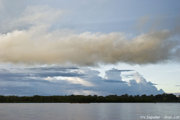
El cielo sobre el río Napo, Yasuní, Ecuador.
La directiva del Ministerio del Patrimonio a la Consejería de Medio Ambiente llegó a eso de a las 5 pm, una hora antes de que la oficina regional cerrara por aquel día. Si no la hubiéramos conseguido antes de que la oficina cerrara, se hubiera retrasado la salida dos días y nuestros planes se habrían ido a pique. A las puertas de un aguacero amazónico saqué los últimos billetes de un cajero automático, compré un cargamento de alimentos para nuestro equipo, eché una siestecilla y luego me encontré al amanecer en el muelle con Dan, Valentí y Mónica, la novia de Valentí.
Después de que el barco se acercara, otros dos extranjeros tomaron fotos en el muelle del trabajo frenético de cargar y coger asiento. Ellos ya tenían sus boletos, pero vieron el caos y el cielo encapotado y decidieron que aquel barco no era el lugar donde querían para pasar las próximas 12 horas.
A los cinco minutos de dejar El Coca ya no había edificios de ningún tipo en la orilla. La lluvia comenzó a caer y una enorme lona negra se desplegó rápidamente y pasó por encima de los que estábamos sentados al frente. Dan y yo nos recostamos contra la lona, sosteniéndola rápidamente contra la borda con nuestras espaldas para tener un techo que se sostuviera tenso sobre nuestras cabezas. La lluvia azotaba el plástico, y debajo de ella me sentía como un niño en su fortaleza: una acogedora sensación de protección y confort en medio de un mundo amenazador. Parecía que la lluvia se detenía, luego continuó y más tarde se detuvo de nuevo. El tiempo pasó rápidamente bajo las nubes.

Bajo el plástico, Dan y David capeando la tormenta. En amarillo, el puntero.
El puntero se situó en la proa todo el viaje, haciendo gestos con la mano para guiar el timonel y rodear los bancos de arena. No le dieron las gracias durante todo el tiempo que no encallamos. Sin embargo, cuando la arena raspó contra el casco y los pasajeros sintieron como piso empujaba hacia arriba contra sus pies, mientras el barco se iba parando, silbaron y gritaron: «Punterooo!» En menos de un minuto el puntero cayó al río. La carcajada siguió durante unos minutos mientras se abría paso de nuevo en la proa con una sonrisa infeliz, con la vergüenza en su semblante. Fue la primera diversión que tuvimos en horas. Nos acercábamos a nuestro destino, Nuevo Rocafuerte, justo al lado de la frontera con Perú.
Continúa en La selva (1a parte).
Words: David Biller. Photography: Valentí Zapater. (Go to the first post or to the index)
Si quieres leerlo en castellano mira más arriba.
The ITT area is in the northeast corner of Yasuní Park. I watched the White House press conference on Osama’s death in the airport then took my window seat on the Dornier 328. The plane started dropping like a lead balloon from the Andean peaks, and the pilot came over the loudspeaker to inform us the sky was “almost clear.” I looked down at the immense cloud cover and begged to differ. (Clear relative to what? A plume of volcanic ash?) Once below the clouds, I saw the biggest forest I’d ever viewed from above. The trees gave way to farming parcels near Coca and, in the distance, a small flash of sunlight reflecting on the the Napo River that I would hopefully soon be navigating.

Sky over Napo River, Yasuni, Ecuador.
The Heritage Ministry’s directive to the Environment Ministry came through at 5pm, an hour before the regional office closed for the day. Had we not gotten that before their office closed, it would’ve delayed departure by two days and torpedoed our plans. With an Amazonian downpour starting to come down, I got the last of an ATM’s cash, bought a shitload of food for our team, snatched a snippet of sleep, then met Dan, Valentí and Valentí’s girlfriend Monica at the dock at sun-up.
After the boat pulled up, two other foreigners on the dock snapped photos of the hectic load job and seat grab. They already had their tickets, but saw the chaos and clouded skies and decided this boat was not the way they cared to spend the next 12 hours.
Even five minutes outside Coca, there were no buildings on the shores whatsoever. Rain started coming down, and a massive black tarp was quickly unfurled and passed up to those of us sitting in front. Dan and I leaned back against the tarp, holding it fast to the gunwales with our backs to have a roof sustained with tension over our heads. The rain slapped at the plastic, and below it felt like a child’s fort: an embracing sense of protection and comfort amid a threatening world. The rain would stop, then resume, then stop again. Time slipped by under the clouds.

Under the plastic, Dan and David weathering the storm. The man in yellow is the «puntero».
The “puntero” (pointer) stood on the bow the entire ride, motioning with his hand to guide the tillerman around sandbars. He got no thanks the whole time during which we avoided running aground. But when sand scraped against the hull and passengers felt the floorboards press up against their soles as the boat came to a rest, they whistled and yelled, “Punterooo!” Not a minute later, the puntero fell into the river. The raucous laughter continued for minutes as he scrambled back onto the prow with a hapless, embarrassed smile plastered on his face. It was the first entertainment we’d had in hours. We were nearing our destination, Nueva Rocafuerte, right beside the Peruvian border.
It continues at The jungle (1st part).


Deja tu comentario